

It’s been awhile since I have tapped away at the keys to talk about my adventures on the Maine trails, and what I have been drinking while doing so. During this time, I have had some pretty significant hiking treks, so there is a lot of catch up on.
In this entry I am going to touch on a hike of the 6-Peak Circuit in Acadia National Park, and a post-hike visit to Atlantic Brewing.
The 6-Peak Circuit was something I researched online. I was looking for a hike in Acadia National Park that would give me the ability to check several of the parks summits off of my list in one shot. I was only able to day-hike, so I didn’t have the luxury of a couple of days to get a bunch of peaks. The 6-Peak Circuit is only lightly talked about online, so it took quite a bit of digging to read some accounts of the trek.
Researching to hike in Acadia is hit or miss. I think the Park wants you to pay for the trail maps, so there isn’t much good to work with on the Internet. This left me with a vague idea of what I was doing scribbled onto a piece of scrap paper, and a fervent hope for good results. I felt somewhat confident in what I had written down as directions to the different trail junctions, and I had planned to stop and grab a map when I got to the park anyway.
With my dog Remy along for the ride, I hit the road around 6:30 and burned up the interstate highway north to Bangor, then headed east toward Bar Harbor, and Acadia. After a missed turn that almost took us into the town of Bar Harbor, we got to the trailhead a little after 10am.
I had failed to stop to get a map on the way in. This caused me to deal with a great deal of confusion starting out. The signage on the trails points to specific areas, but not to specific trails, and the layout wasn’t as obvious to figure out as it seemed online.
The outer perimeter of the park is circled by carriage roads. I didn’t understand what this meant while researching it. But they are, quite literally, roads that horse carriages go on. They are wide, graveled paths and they essentially connect to all of the major hiking trails in the park. The signage on the carriage roads was completely unhelpful though, and it took a few minutes to sort things out.
I met another poor soul who was as confused as I was, and we agreed to team up and walk along together until we figured it out. She had a dog with her as well, and was a visitor from out of state who was staying with friends for a few days. She was urged by her friend to day hike while she was in the area, so she ventured out unprepared for the confusion, much like myself. Her goal was Parkman Mountain, which was also on my agenda, but second after a stop on Bald Mountain.
After a short walk, we found the trail to Parkman, so we said our goodbyes, and I continued onward to the trail to Bald Mountain, which I now knew was just ahead for sure. The trails themselves were very clearly marked by signs. It was just the directional signs on the carriage roads that caused things to get messed up. Shortly after the trail to Parkman, I came to the junction to the trail I was looking for and turned into the woods.
The hike up Bald was fairly direct, mostly roots and rocks, and woodsy. Eventually the trail opened onto another carriage road. There are upper carriage roads that connect to the lower ones. This was sort of the midpoint up the mountain. I crossed the road and hopped back on the trail, and very quickly got to a point where I was climbing up rock ledge, and I started to get some pretty spectacular views of the mountains to my back, and the ocean. The final ascent to the summit is basically completely open rock, with a last little push right before the very top.


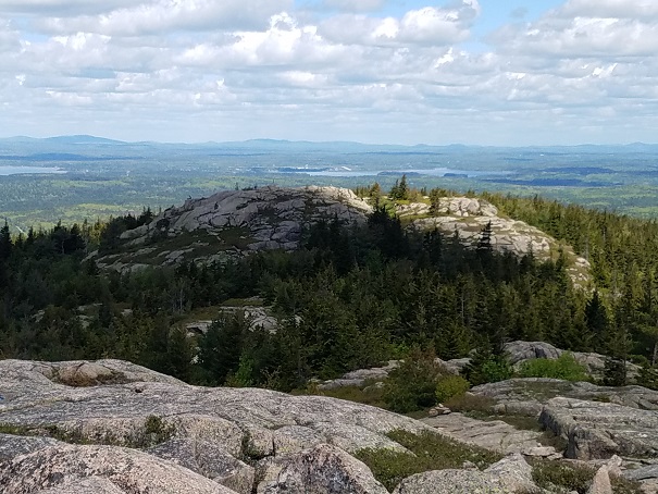
The summit of Bald was pretty great, in spite of its lowly stature. There were excellent views of nearby Norumbega Mountain, the vast ocean, Penobscot Bay off to the west, Blue Hill, and the Parkman Mountain summit a seeming stone’s throw away. This mountain would be a worthy day-hike for someone not interested in putting in a lot of hours, because the hike wasn’t tough or long, and the payoff was very good.
Parkman Mountain summit from the summit of Bald.
Parkman summit was real close and looked really cool that nearby. I didn’t stick around for long on Bald, because I had a lot of ground to cover still. Remy and I started down the trail to that peak. My directions were all adding up, which was nice. I had estimated distances, and the names to the trail junctions to work off of, and to that point it was working. A short distance down and we joined up with the Parkman trail leading to the top. Parkman was very similar to Bald Mountain, in that it was wide open with great views with a little bit of bouldering and ledge climbing on the last push up. From Parkman there’s a great view of the Camden Hills to the west, which was obscured by Norumbega from the peak of Bald.
Gilmore Peak was the 3rd stop in the circuit, and was so close by that it seemed like it would be a pretty easy transition to get there, much like it was from Bald to Parkman. Boy was that wrong! The trail down from Parkman was a very direct downward climb, much steeper than I was expecting it to be, and it took a while to get down. Once down, it turned into a leisurely walk through the woods for a bit, before beginning the climb up Gilmore. At this point the trail reminded me a lot of Grafton Notch, with its gnarly roots and rocks to climb over in the woods.
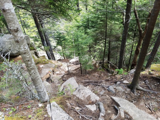
The trail down from Parkman over to Gilmore.
Looking up the trail to Gilmore Peak summit marker.
Looking back to Parkman from Gilmore Peak. The peaks of Camden Hills on the horizon.
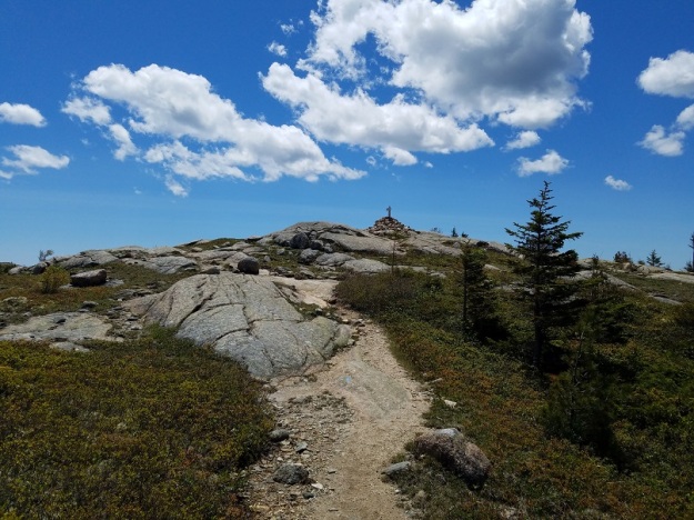
We eventually got out onto some flat rock ledges, and the trail was pretty much a gradual climb to the summit marker. 3 summits achieved in under an hour and a half, I was feeling pretty good about my progress. The next peak was the largest of the six, Sargent Mountain, but it was only just 6/10ths of a mile away, so it didn’t seem like it would take too long to get there.
The trail between Gilmore and Sargent was actually quite nice and beautiful in parts. A stream ran alongside the trail for a good portion of it on the climb to the summit, and here we met up with our new friends from the beginning of the hike coming down the trail. They had already visited the summit and were heading back the same way they had come in.
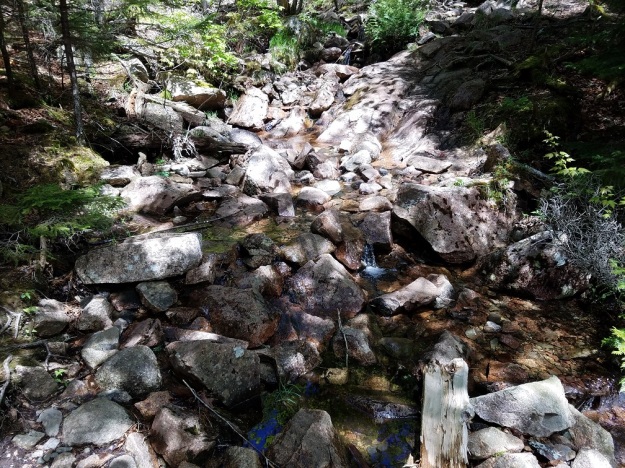
Stream alongside the trail to Sargent Mountain.


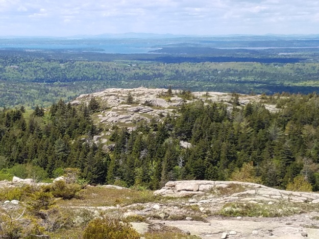
At just after 2 hours we were standing on the summit of our 4th mountain. Sargent was arguably the prize of the entire trip, with a huge open summit with 360 degree views. The previous 3 peaks had the more prominent Sargent blocking views on the east side of them, but Sargent had no such rivals in the way. Cadillac Mountain to the east was conspicuous, but wasn’t really blocking much with only 160 feet of additional elevation. It would have been nice to spend more time on Sargent, but I felt guilty even taking 20 minutes for pictures and a snack, because we still had some ground to cover to get to the other 2 peaks of the 6.


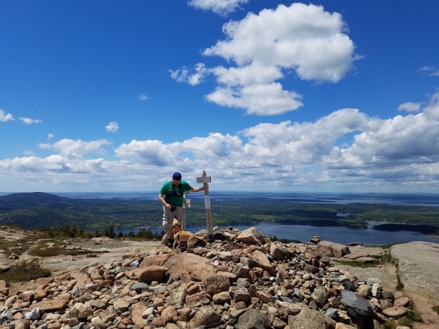
Remy and I on the summit of Sargent Mountain.
There were a couple of choices of trail that we could have taken from Sargent to get to Penobscot Mountain, the next one in the plan. I had chosen the Sargent East Cliffs trail, which sounded exciting. This turned out to be a big mistake. As we started out we could see Penobscot Mountain nearby, and could even make out the summit marker at the top. The Sargent East Cliffs trail started out innocently enough. A fairly direct climb down brought us to some open ledges that walked along what seemed to be cliffs a little further down. As we walked along, Penobscot started drifting further away from us instead of getting closer. This was somewhat alarming, but didn’t turn out to be the worst of my problems. After a time the trail started taking a more direct downward descent. We ran into a couple here who appeared to be very winded and wanted to be at the summit. I informed them that they had a way to go still, which did not bring them much joy. I learned quickly why they were in the state they were in, as the trail continued down into a pretty aggressive descent of, essentially, a cliff. In my mind I had imagined the trail ambling along the tops of cliffs on a ridge over to Penobscot Mt. What I got instead was a pretty hellish descent that railed on my knees and was exhausting, made the worse by having to help a short-legged dog down the trail that had no business being there. There were parts where Remy just did not know what to do, and I had to get below him, and physically lower him to the next safe spot. It was pretty crazy. And tiring. I was very relieved to finally get down from there, and even more so when I started to hear the stream in the distance that I knew we had to cross. Lesson learned from this? Don’t just research the hike, research the individual trails!
Deer Brook. The trail runs along to the right of the brook.
We reached the Deer Brook Trail and I was flat out cooked. My legs felt like Jell-O and I had no desire to continue on. We were passed by a couple and their dog who were heading up to Penobscot from the Deer Brook trailhead. After they passed us, I had to stop. My knees hurt so much from climbing down that damn cliff that I had to take the weight off of them. I got down on my hands and knees and stayed there for a good 5 minutes just letting my knees rest. If someone had come along, they probably would have thought I was in cardiac arrest. I felt a little better after that and pushed onward. We eventually came to a junction with Penobscot Trail, where the left turn was a tenth of a mile to the summit of Penobscot, and the right turn went back toward Sargent (which was less than a mile away, a trail that would have been much easier on me than what I had just done).
We climbed the short trail to the summit of Penobscot and were treated to another pretty open view, this time in the direction of the ocean and the surrounding islands. The summit was large, and would have been good to explore, but I didn’t stick around long, despite being tired. It had taken us 90 minutes from the summit of Sargent to Penobscot, so now time was becoming an issue.
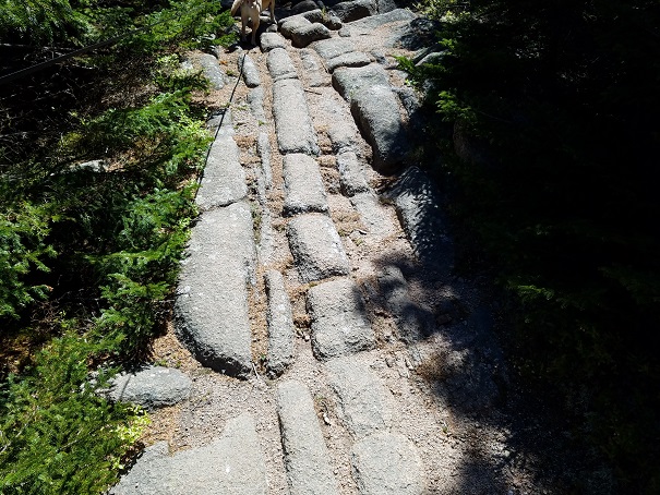
Interesting rock striations on Penobscot Mountain.
We climbed back down to the junction with Deer Brook Trail, and continued on Penobscot Trail back toward Sargent, where I knew we would meet up with the trail that would take us to our final mountain. Before that though, we came to a small tarn called Sargent Pond, where I let Remy off his leash so he could swim. He wanted to continue on the trail, but when I let him off his leash and said the word “swim”, he knew what to do. He dove in and made a couple of loops out into the deeper parts of the pond, freaking me out a bit. After yelling at him to come back, he swam in and then climbed out, to jump right back in again. He did this a few times, and then I leashed him back up and continued up the trail. That was a nice pit stop, and a cool diversion in the middle of the hike. Had it been hotter out, I may have jumped in too!
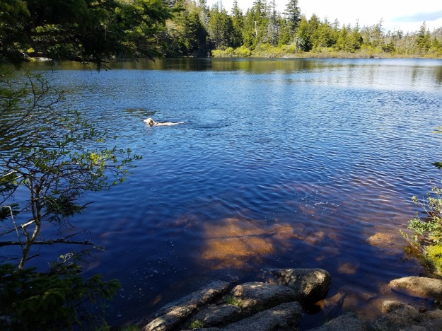
Remy’s swim in Sargent Pond.
We quickly made it to the junction with Sargent South Ridge Trail. This would have been the ideal way for us to have come from Sargent and would have saved a bunch of time. We turned left at the sign and headed away from Sargent Mountain toward our final destination of the horribly named Cedar Swamp Mountain. This trail was mostly a gradual descent on the long ridge of Sargent, with a couple of viewpoints, and a good view back at Penobscot, down to the junction of Amphitheatre Trail, which was to be our way out.
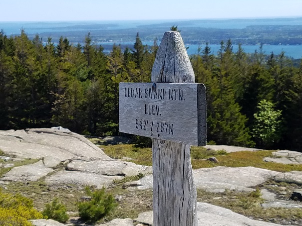
Remy was clearly showing signs of fatigue here, and I actually debated just heading out on Amphitheatre, but the summit was just a few tenths of a mile away, so I decided to go for it. Before long we made it to the top of our 6th and final peak. Cedar Swamp Mountain was the second smallest (Parkman was 1 foot shorter), and the least scenic of the six. The view was OK, and the summit had some space to it, but overall it wasn’t much when compared to the rest we had visited.
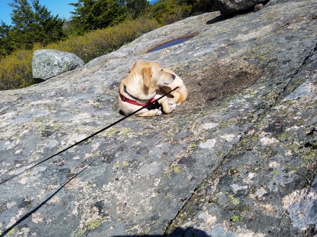
Remy taking a much needed snooze on the summit of Cedar Swamp Mountain.
After I finished taking pictures, I turned around to find Remy curled up in a ball on a sandy spot with his eyes closed. I laughed, but then decided that he might have the right idea. I set aside my pack, and laid down on the rock for a while and rested. After maybe 5 minutes, I decided we needed to get up and get moving though, as we still had some distance to cover before we were out. Much to the dog’s chagrin, we started down the trail from the summit. This was a bit of a struggle for him, because he was just checked out and wanted to be done. At one point, I got down off of a couple of rocks, and he was still standing on top. I looked back at him and he was just standing there looking at me, then he slowly closed his eyes like he was sleeping standing up. It was both sad and hilarious at the same moment. I picked him up and lifted him down, and coaxed him down to the Amphitheatre junction.
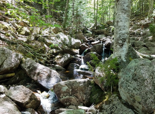
From there, Remy was fine, as the trail was mostly flat with a slight downward grade. We eventually crossed the brook, and the trail met up with Hadlock Brook Trail where it turned a little more downhill, following the brook down to where it intersected with the upper carriage road. At this point, I was delighted to come upon a great waterfall that passed under a bridge. I had read about Hadlock Falls online and hadn’t realized that my course was going to take me right to it. It’s one of only a few waterfalls in the park, and it is a big, picturesque scene.
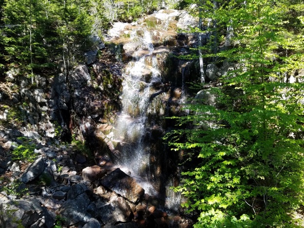
Hadlock Falls.
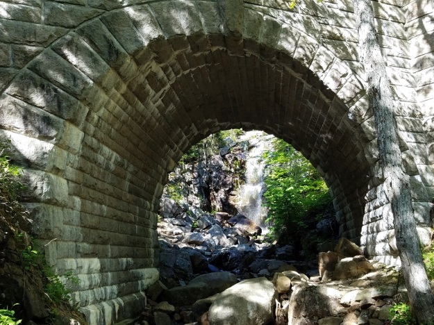
Hadlock Falls from under the carriage road bridge.
I took a few minutes to take photos from on top and under the bridge, and then decided that rather than continue down the Hadlock Brook Trail, that we were going to wimp out and walk the carriage road. I didn’t have a map, or any directions relating to the road, but I assumed that it must eventually lead back to the lower road and the trailhead.
The carriage road walk was much better on tired legs. It was flat, and graveled, and was a quick walk. As I thought it would, it wound down to the lower road, and right back to where we started out. 6 Peak Circuit complete!
All of my grandiose plans of spending the day in the National Park, taking in some other sights, and visiting downtown Bar Harbor were pretty much trashed because I am too slow of a hiker. The one stop I knew I could still make on my timeline was Atlantic Brewing, which was right on my way back. After a nice long rest and water break, I loaded up the vehicle, got Remy comfortable on the passenger seat, and got back on the road to Atlantic.

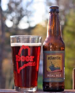
Atlantic is a well-established brewery in the state. Not huge, by any means, but they’ve been around a good long time and have a respected name. To that point, they’re doing well enough that when you visit their tasting room, the samples are free. They are one of the only places in the state, besides Allagash Brewing, that does this that I am aware of. The guy I spoke to at the counter was very informative, talking to me about the different beers, the history of the place, and about the National Park. I sampled the Bar Harbor Real Ale, 04609 Double IPA, Coal Porter, Bar Harbor Summer Ale, Bar Harbor Blueberry Ale, and Mount Desert Island Ginger. The standouts for me were Real Ale and Summer Ale.
Bar Harbor Real Ale is a flavorful Brown Ale with a caramel malty undertone and slightly smoky aspect to it. I’ve had this one before, and it never disappoints. The Summer Ale was just a delicious light beer. Crisp, with a lot of flavor, and would be a good “lawnmower beer”. I am starting to get into session beers quite a bit. There seems to be a movement amongst craft brewers to make really flavorful light beer, and I am enjoying it.
On my way out the door, I purchased a 6-pack of their house-made sodas, and also a few bottles of their Scottish Ale, and Brother Adam’s Bragget, two beers which were unavailable to sample. I passed up on getting some BBQ from the food stand they have next to the tasting room, as I just didn’t have time to wait, but it smelled amazing.
A Braggot (or Bragget) is a fairly ancient recipe that combines mead and beer to make an interesting hybrid. I got around to drinking one of them a week or so later, and let me tell you, this concoction has some kick to it. At 10%, Brother Adam’s Bragget was no joke, and I ended up splitting it with a friend to keep myself in check. It’s very good, and not distributed widely, so if you’re ever able to visit the brewery, I recommend grabbing a bottle or two (or three). I haven’t had a chance to drink one of the Scottish Ales yet. Their soda, it should be noted, was quite excellent. I got the Blueberry Soda and Root Beer. Both were great!
My ratings of Atlantic Brewing’s beer on Untappd.
The drive back was long, and was accentuated by thunderstorms with areas of torrential downpours that slowed traffic to a crawl. I was thankful those storms waited until I was off-trail to roll through the state. As I hit about the halfway point, the rain had passed and a massive rainbow revealed itself along the highway. At a stop for gas I snapped a few pictures. It was easily the most brilliant rainbow I have ever seen, and appeared as a full arc.


So, in summary, the 6-Peak Circuit is a great hike. For someone who is a stronger hiker than I, it would likely not be particularly difficult I don’t think, but it surely kicked my butt. It was somewhere around 7.5- 8 miles total, and visited some great smaller peaks with fantastic views. I would recommend not climbing down the Sargent East Cliffs Trail unless you have extra time, and don’t have a dog or children with you. Atlantic Brewing was a great post-hike stop with excellent brews, and free samples. All of this made for a great trip.
I will definitely make another trip to Acadia this fall, after the summer crowds have gone away, to check out some of the other attractions in the Park and maybe get into town to see what is going on there.
In the next installment of the blog I will recap a recent hike up Saddleback and The Horn in Rangeley, to cross a pair of 4000 footers off of my list. Until then, pop the top on a good one and get out and do something!

Pingback: Trails & Ales #12- Saddleback & The Horn, Rangeley, Maine 6/20/17 | mikesbeeradventures